Heading for the landing page here
Sub heading for the heading to go here so it explains it. bit more
Talk to Geotec
Lorem ipsum dolor sit amet, consectetur adipiscing elit, sed do eiusmod tempor incididunt ut labore et dolore magna aliqua. Dolor sed viverra ipsum nunc aliquet bibendum enim facilisis. Aliquet lectus proin nibh nisl condimentum id. Scelerisque fermentum dui faucibus in. Sed id semper risus in hendrerit.
Eu feugiat pretium nibh ipsum consequat nisl vel. Congue eu consequat ac felis donec et odio pellentesque diam. Amet justo donec enim diam. Non pulvinar neque laoreet suspendisse interdum. Varius morbi enim nunc faucibus a pellentesque sit. Ut aliquam purus sit amet. Pretium lectus quam id leo in vitae turpis. Amet venenatis urna cursus eget nunc scelerisque viverra mauris. Pretium viverra suspendisse potenti nullam.
Call to action strip to go here.?
Geotec Surveys works with energy distribution providers and their contract partners to carry out full underground mapping and topographical surveys, as well as marking our surveys within substation environments, as well as in public roadways and footpaths.
In addition, the teams also have relevant water safety passports and EUSR water hygiene cards to allow Geotec to work at a range of water treatment sites.
Geotec hold the necessary Achilles UVDB & Verify accreditation to allow them to work in this sector
As an accredited RISQS-certified supplier, Geotech PTS certified survey teams assist railway contractor clients in providing underground mapping surveys within trackside and non-trackside environments.
This includes surveying station platforms, subways, car parks and other areas around and within station buildings, primarily providing PAS 128 & utility mapping GPR Surveys.
Much of the work within this sector takes place outside traditional working hours - at weekends and at night.
Geotec assist housing developer clients, usually in scenarios where they need to know where utilities and services are located adjacent to their site, to aid in designing their connections to them.
A full utility survey is usually required when developing a brownfield site, such as previous industrial estates, petrol station sites and other such locations.
GEOTEC Surveys also support local authorities & councils in providing PAS 128, utility mapping & topographical surveys for a range of projects in varying locations, including housing estates, care homes, recreation grounds & parks, city centres, council offices and highways environments.
Hospitals, schools and universities can often comprise older sites, which have been built up over the years, making these complex to survey.
Geotec have familiarity in completing full surveys over entire campuses as well as surveying smaller piecemeal areas on and as and when basis. Geotec need to work closely with the estates departments to identify the best times to survey these sites (especially when working near A&E departments), whilst they can also have additional services, not usually found in other environments, such as steam, oxygen and large service trenches.
Geotec assist housing developer clients, usually in scenarios where they need to know where utilities and services are located adjacent to their site, to aid in designing their connections to them.
A full utility survey is usually required when developing a brownfield site, such as previous industrial estates, petrol station sites and other such locations.
Geotec carry out numerous smaller surveys for telecommunications clients wishing to make use of existing infrastructure, such as phone mast sites, around existing telecoms cabinets and where new buried infrastructure is required.
Geotec can complete several sites a day, depending on the localities of each one.
Geotec work both landside and airside at several airports, carrying out full underground mapping surveys for buried services and utilities, most notably at London City and Luton Airports.
Geotec have also completed Vehicle-Mounted GPR Surveys to detect voiding and unconsolidated ground beneath runways and other areas of hard standing.
Geotec have assisted several clients at Heathrow within hangar and fire station locations, where and when required, providing PAS 128 surveys in line with their specific CAD standards and survey protocols
Geotec support clients installing new buried services infrastructure across former and existing barracks sites and has surveyed the whole former MOD sites before their release for housing.
Geotec have undertaken a large survey at a local MOD site, detecting & mapping buried services and utilities, as well as old building lines to assist the demolition contractor.
These sites have a variety of high-value infrastructure running through them, and prior to breaking ground, it is imperative to understand the location, depths and types of buried services within the survey area.
A client, Geotec, supported as part of a large survey, informed them that they helped them avoid a data cable responsible for the transfer of millions of pounds per minute.
These are complex sites with a higher density of buried services and utilities than usual, where a high specification survey is required.
Geotec Industries
- Energy & Utility Sector
- Data Centres & Business Parks
- Railway
- Public Sector, NHS & Education
- Housing
- Telecommunications
- Airports
- M.O.D
- Data Centres, Business Park and Industrial Estates
Call to action strip to go here.?
Haverfordwest High
School & Milford
Haven Secondary School
19 JUNE 2019
Duis aute irure dolor in reprehenderit in voluptate velit esse cillum dolore eu fugiat nulla pariatur. Excepteur sint occaecat cupidatat non proident, sunt in culpa qui officia deserunt mollit anim id est laborum.
Call to action strip to go here.?
Testimonial strip to go here
CLIENT FEEDBACK

“The operatives were very professional in their duties and during an issue with a gas alarm they followed the correct evacuation procedure.”
— PROJECT MANAGER
GPR Survey FAQ’s
Below are a list of questions that we are asked on a regular basis about GPR Surveys for Utility Mapping:
A Ground Penetrating Radar (GPR) Survey is used to detect changes in ground density.
These changes may relate to:
Buried Services & Utilities – we utilise GPR every day as part of our utility surveys and it is an integral tool in detecting plastic gas and water, as well as other services such as drainage.
Voiding and Unconsolidated Ground – voiding such as tunnels, cavities or disturbed / looser ground.
Significant buried features such as tanks, foundations or other substantial obstructions.
Saturated ground conditions – this is identified by a significant degradation of radar data. When paired with a utility survey, this may identify where leaks could be present. Voiding may be associated with wash.
The cost of a survey depends on a number of factors:
- Objective of the survey
- Depth survey needs to penetrate
- Size and nature of the survey area
- Geographical location of the site
- Whether any out-of-hours working or traffic management measures are required.
Utility Mapping Surveys have a tolerance of the 10% of the depth down to 2m below the ground surface.
This tolerance increases significantly beyond 2m.
A number of factors affect the accuracy of the Ground Penetrating Radar, such as ground conditions. For example, dry sand is the best medium for getting the most from a GPR system, whilst wet sand is the worst!
Ground Penetrating Radar on its own cannot tell you what a specific feature or anomaly may relate to. Use of radio frequency detection or excavation can assist in identifying what anomalies or unidentified linear targets may be.
GPR cannot be used where vegetation or obstructions are present and is not practical where long grass or uneven ground is in situ.
The presence of reinforced concrete also limits the effectiveness of GPR.
Ground Penetrating Radar is a versatile tool which can be tailored for a range of applications.
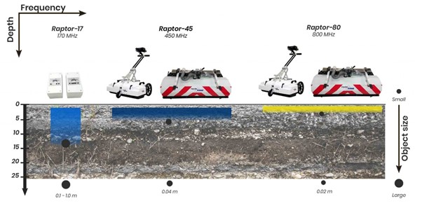
We use a handheld GPR system which has a depth penetration of 400mm below the ground surface for concrete analysis and locating anomalies in small, often, internal spaces including underfloor heating pipes and voids.
There are antennas which offer high resolution at shallow depths.
Next, we have dual antenna systems which provide high resolution output at a shallow depth and a deeper depth.
Our standard set up consists of a 350MHz hyper-stacking digital antenna or 400MHz antenna designed for detecting buried services and utilities.
We can then use 200, 270 or 100MHz GPR antenna for deeper depth penetration up to 10m, subject to ground conditions.
The smaller the feature, the harder it is to detect. The deeper we penetrate the larger the feature has to be for it to be picked up in the radar data. This is displayed by the below graphic:
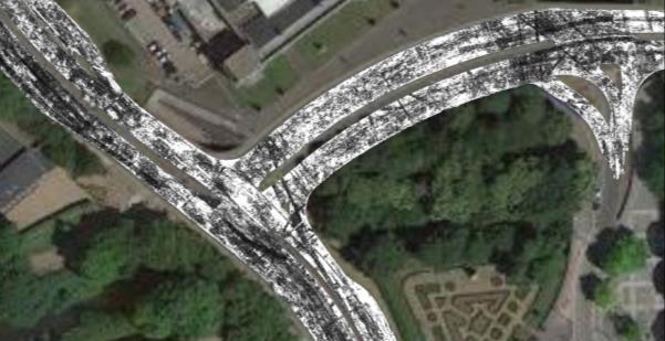
Vehicle-mounted GPR surveys are designed to cover large area or highways quickly. This is completed using a multi-array or multi-channel system.
GEOTEC Surveys indicate the presence of an anomaly by the below turquoise hatching. The depth to the top of the anomaly is also shown.
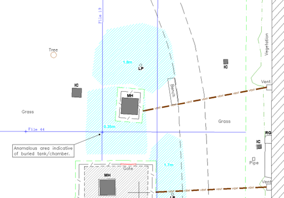
Where enough evidence is present, we shall also attempt to identify what the anomaly may relate to.
GEOTEC can also provide an accompanying report which includes some extracts of the data collected using the Ground Penetrating Radar System.
We would highlight which file the extract relates to and highlight the area of interest using the green boundary line on the below example.
File 44:
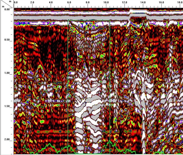
We also use other software packages, where required, which processes the data to enable us to view it in line with the below representations:
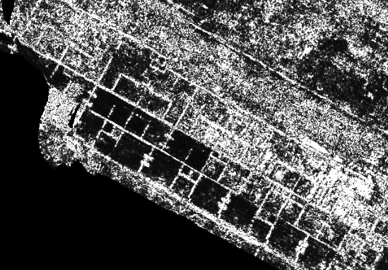
The above extract shows the presence of former building lines on an old barracks site.
The below extract shows the positions of buried services and utilities on a highways project in Wales, overlaid onto Google Earth data.