
Electrical Imaging & Resistivity (ERT)
Electrical Imaging & Resistivity (ERT)
Mapping the ground in detail, detecting anything from fine, shallow details to
larger structures hidden far below.
Bedrock profiling using imaging/ resistivity (Electrical Imaging & Resistivity) assists clients to:
- Ensure piling is securely installed
- Map the extent of oil pipeline and water leaks
- Locate the water table
- Provide evidence of fissures/caves/tunnels/ mines
- As a follow up to EM31 / CMD electromagnetic surveys to offer more information on key areas highlighted as part of the initial survey.
- Cross-reference borehole data with the survey results to offer a greater understanding as to their findings
Electrical Imaging and Resistivity
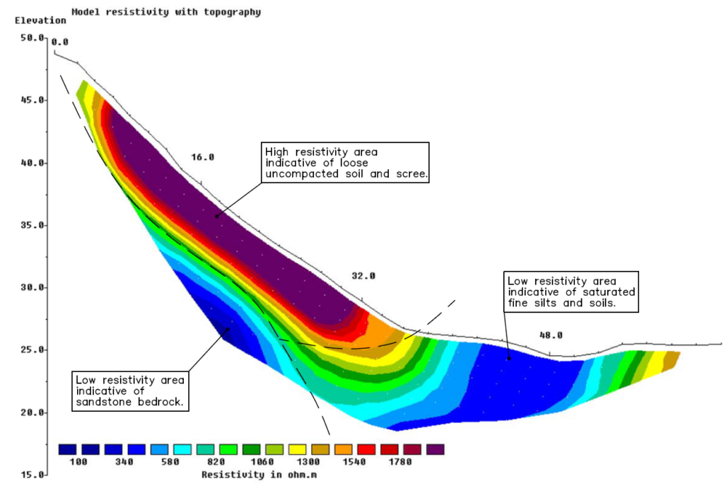
Below is an example of a Resistivity Survey. A full cross-section can be provided showing the contours and make-up of the ground reaching a depth of up to 30m into the ground.
The depths achievable are subject to how much space is available to lay horizontal lines of electrodes and the spacings available.
The closest together the spacings, the shallower the survey will penetrate, resulting in smaller features being detectable.
The deeper the penetration, the larger the features need to be in order to be seen in the data.
Want to know more about ERT?
Underground
Mapping
An example of a survey where Geotec have several unidentified ground penetrating radar targets present, as well as confirmed buried services and utilities.
This tool also allows Geotec to confirm the presence of metallic and conductive services that have already been detected through radio frequency detection / electro-magnetic locating (RFD / EML).
GPR Surveys
Electromagnetic Surveys
Talk to Geotec


Follow Online
© GEOTEC SURVEYS – UNDERGROUND MAPPING


Website designed and produced by expect more – part of snap-marketing.co.uk
Website designed and produced by
expect-more.co.uk