
Where is GEOTEC based?
GEOTEC Surveys Ltd. has 2x physical offices from which our survey teams and office support are based:
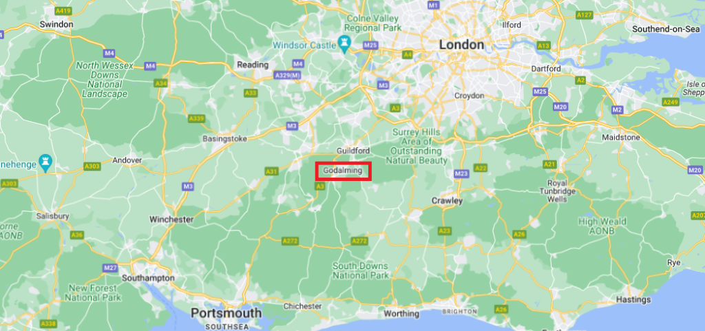
Godalming in Surrey, England
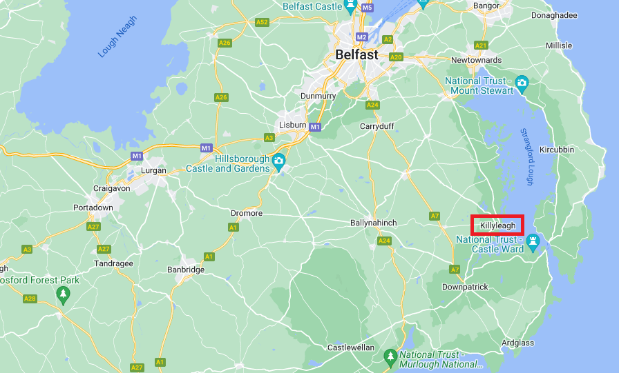
Killyleagh in County Down, Northern Ireland
What areas do GEOTEC cover?
GEOTEC Surveys Ltd. operates nationwide, out of the 2x offices, detailed above.
We have been around for 25 years and one thing that sets us apart, other than our knowledge of Underground Survey Mapping, is the importance of local knowledge. Our Surrey office, which is also our Head Office, looks after England & Wales. Whereas our Northern Ireland Office covers Northern Ireland and Scotland. Making sure each area gets the highest levels of surveying expertise.
We are also happy to meet clients onsite prior to works taking place so that we can fully understand your requirements, the site and the scope of works, prior to submitting a quotation.
We have also worked Globally on projects in Europe and the Middle East
Can GEOTEC provide records for my address?
GEOTEC Surveys Ltd. may be able to provide existing records information relating to your address, however, we would require a marked-up site plan showing the area you would like us to cover and will work with our statutory records information provider to assist. Payment would be required upfront unless you are a business. To find out more about this then ‘contact us’. We will be more than happy to help you with the processes.
We can also offer a full records search, covering all possible providers or, if preferred, concentrate on mains Electric, Water, Gas, Openreach (BT), and Drainage.
Who are my Utility Providers?
GEOTEC Surveys Ltd. will not be able to identify who your utility providers are and would encourage you to contact Ofgem & Water UK as per the below:
How much does a GPR Survey (ground penetrating radar survey) cost?
GEOTEC Survey’s fee for carrying out a Ground Penetrating Radar Survey is determined by:
- the objective of the survey (i.e. what are you looking for, for example, buried services & utilities, voiding, obstructions, etc)?
- depth penetration required
- perceived congestion of services present within the survey area
- size of the site
- site location
- whether other add-on services are required, such as Traffic Management
- whether out-of-hours working is required
- existing information such as topographical survey backgrounds or existing utility records
See Previous GEOTEC GPR Survey Examples.
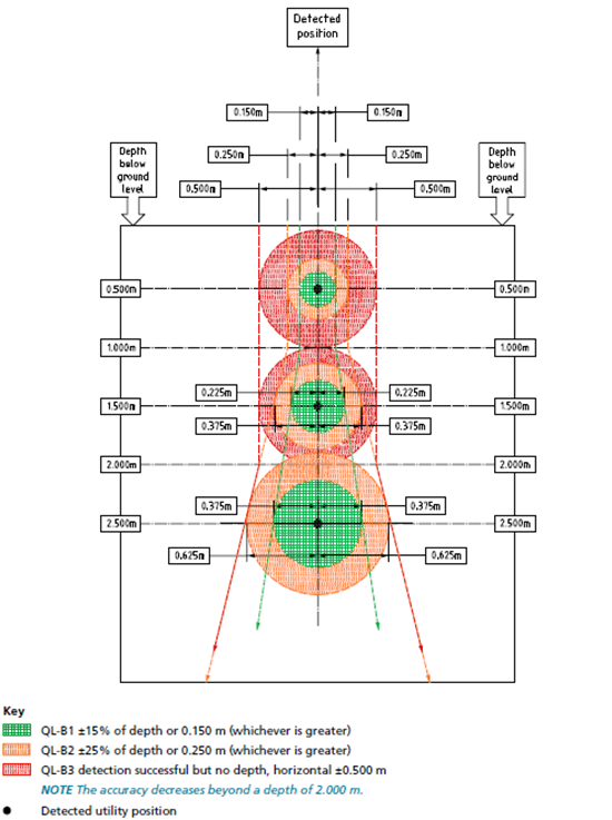
How accurate is a ground-penetrating radar survey?
The general rule for our GPR Surveys is 10% of the depth. The deeper we penetrate, the less accurate the survey becomes. A visual example from PAS128:2022 is shown below.
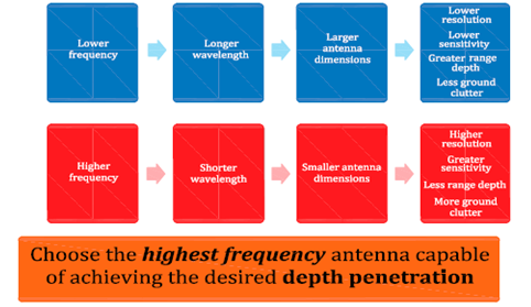
We do however use multiple tools to penetrate to deeper depths, with greater resolution, including specifically designed GPR antennae, such as a 270MHz or 100MHz system, as well as dual antennae.
There are also Geophysical tools that we use to penetrate to deeper depths such as a CMD Electromagnetic Meter (Multi-depth Electromagnetic Conductivity Meter).
What can our GPR Surveys detect?
- Buried services & utilities (metal and non-metal), depending on size, depth, and other site considerations.
- Voids and unconsolidated ground conditions.
- Buried tanks, cellars, basements, graves, and other such features.
- Saturated Ground.
- Reinforcing / Rebar as well as other structural components including foundations, pile caps, and building lines.
PAS 128 indicates that “GPR can detect utilities that Electro Magnetic Locating (EML) cannot, such as plastic gas and water pipes, while also finding metallic pipes and cables.
It can also detect other kinds of subsurface features that might be related to utility installations, such as the trenches in which they are laid; protective capping layers (e.g. reinforced concrete); or the concrete casing that might surround pipes or ducts.
However, GPR Surveys cannot be guaranteed to detect these features, and like any geophysical method is subject to several constraints and limitations”.
For more information about the methods, constraints and limitations of GPR Surveys, please Contact Us.
Can ground-penetrating radar go through reinforced concrete?
According to PAS128:2022, “GPR cannot penetrate metal.
When it encounters metal all the GPR energy is reflected to the receiver.
This property of metal can be useful when looking for metallic pipes or cables, as they tend to stand out in a GPR profile, but it has other consequences.
If targets of interest are buried below a metallic object, they would not be able to be detected.
Utilities can sometimes therefore be hidden beneath other utilities or metallic objects. This is especially relevant on sites with lots of reinforced concrete.
If the reinforcement is quite closely spaced, the GPR signal might be blocked from looking deeper, than the first layer. This means that targets of interest would not be detected if buried under the rebar.
High-frequency antennae can look deeper than the reinforcement if their wavelengths are shorter than the rebar spacing, but these systems tend only to be able to penetrate to depths of around 200 mm to 500 mm, and this is usually too shallow to be confident of detecting utilities that might be present.”
In addition, Radio Frequency Detectors also struggle to see beyond reinforced concrete.
The impact of reinforced concrete on the survey can only be assessed on a site by site basis, at the time of the survey.
How deep can a GPR penetrate?
With 25 years of Underground Mapping experience, we use different antennae to penetrate to different depths, however the resolution decreases, the deeper we penetrate, meaning that smaller features can remain undetected. The below graphic, taken from PAS128:2022 shows this.
We can combine a range of GPR antennae to search for features at a variety of depths to best meet your needs:
- Handheld GPR System 0-450mm (below ground level)
- Shallow antenna 0-1m
- Standard antenna 0.1-3m – this is the primary tool we use for utility mapping surveys
- Deeper antenna 2-10m
- Dual frequency antenna (250MHz & 800MHz)
We are however able to increase the resolution at working with deeper depths using Hyper-stacking digital antennae and multi-array systems, where available. See our Example Survey Results.
The standard depth of our surveys is 2m below the ground surface.
Do you have Ground Penetrating Radar for sale?
As a service provider, GEOTEC Surveys Ltd does not sell or provide hire solutions relating to GPR survey equipment.
Our highly qualified and extensively experienced survey teams will attend the site and carry out the GPR survey on your behalf, providing a drawing as an output, as well as a written report in some instances.
As members of Euro GPR, we are certified to use Ground Penetrating Radar (GPR) and would always encourage employing a qualified and experienced Survey Company to meet your survey needs. We have 25 years of experience, which is invaluable when collecting data and especially in the interpretation and analysis of it.

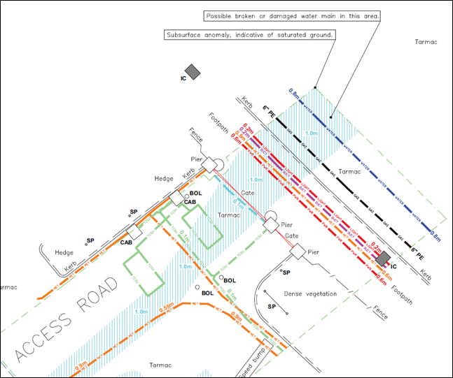
Detecting water leaks in underground pipes
Whilst GEOTEC Surveys Ltd. is not a specialist “Leak Detection” survey company, we can detect and map the routes of the existing buried services onsite and coupled with a GPR survey, identify any areas of voiding, wash or saturated ground, which may relate to the leak in question. Please see below the example survey results:
These are just some of the frequently asked questions that we receive. If there is a question that you have that is not mentioned above or you would like to find out more about something mentioned above please do contact us or call 01428 686168 / 07917 536904. We are also available over WebChat (during office hours).
 +44 (0)1428 686 168
 enq@geotecsurveys.com


