
3D Laser Scanning
3D Laser Scanning
Accurately collect point cloud survey data, from which the relevant data is extracted to offer floor plans, plan views, elevations and sectional analysis for a range of features.
Where required, Geotec supplement underground mapping surveys with 3D laser scanning to provide precise dimensional details for various features, as shown below.
Want to know more about 3D Laser Scanning?
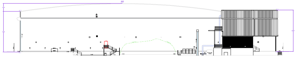
Example of elevations by 3D laser scanning.
3D Laser scan data can be displayed in 3D AutoCAD within the model space as well as 2D plan view format.
Geotec complete 3D laser scans to accurately collect point cloud survey data, from which the relevant data is extracted to offer floor plans, plan views, elevations and sectional analysis for a range of features.
Plan view drawings are extrapolated from this data so that the client is provided with the specific information and level of detail they require for the features requested.
This can relate to substation equipment (internal or external, such as transformers, reactors, plant & bunds), bridges, footbridges, external building elevations and internal room sections & elevations.
This above-ground survey data compliments our Underground Mapping GPR Survey Information and can offer a context as to the routes of buried services and utilities once they exit the ground surface.
In many instances, services run above ground, along the walls of buildings or in racks and cable troughs before or after entering buildings and a 3D laser scan can capture this data.
3D laser scanning can also assist when surveying inside basements where the services run along the ceilings – this is particularly true where under-croft parking is in situ and can be completed in conjunction with a tag and trace survey.
Advantages of 3D laser scanning:
- Quick data collection
Ideal for features where complex detail is required - Collects data to a high level of accuracy
- Can work in tighter areas that traditional survey means cannot
- Data can be collected remotely
- Data collected to OSGB 36 to X, Y & Z
- Reduces the likelihood of missing features
Underground
Mapping
An example of a survey where Geotec have several unidentified ground penetrating radar targets present, as well as confirmed buried services and utilities.
This tool also allows Geotec to confirm the presence of metallic and conductive services that have already been detected through radio frequency detection / electromagnetic locating (RFD / EML).
2D Topographical Surveys
3D Topographical Surveys
3D Underground Mapping
Talk to Geotec


Follow Online
© GEOTEC SURVEYS – UNDERGROUND MAPPING


Website designed and produced by expect more – part of snap-marketing.co.uk
Website designed and produced by
expect-more.co.uk