
Service Clearance & Marking Out Survey
As well as carrying out a full utility mapping survey, Geotec provide CAT scans whereby the position, type and depth of buried services & utilities are sprayed onto the ground surface.
Geotec can either survey a whole area or provide service clearance for numerous invasive ground investigation (GI) areas or positions. This includes borehole, window sample, trial pit or core sample locations.
Want to know more about Service Clearance?
Although a drawing is not provided, the methodology used is the same (use of EML, cover lifting and GPR) as for any other utility mapping survey with GPR targets sprayed onto the ground surface in real time.
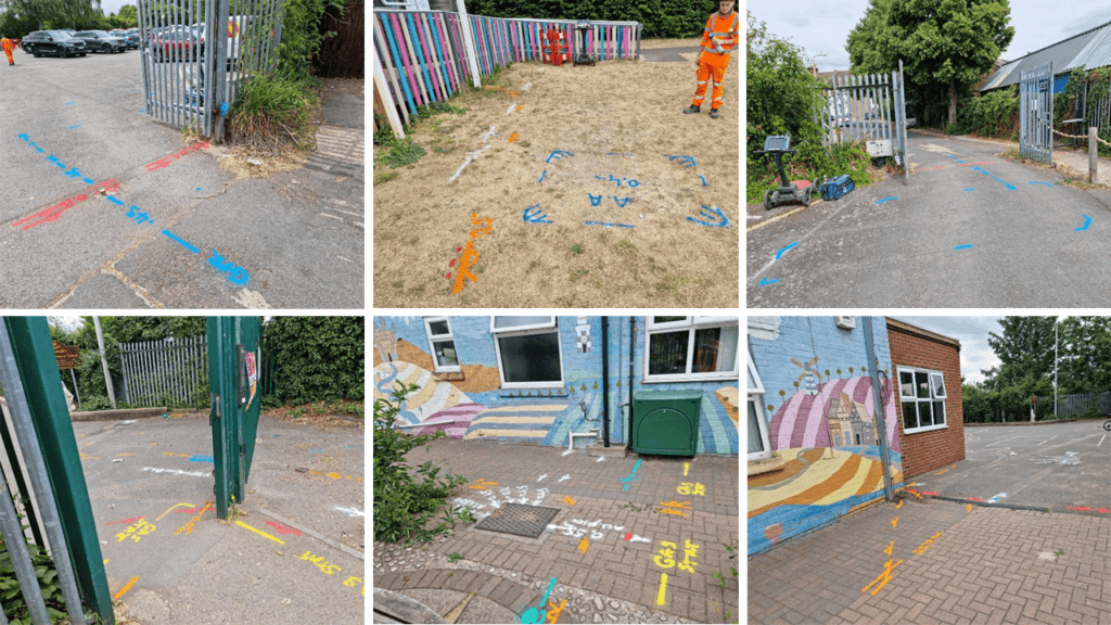
A mark out survey provides a cost–effective alternative when smaller excavations are planned, such as the installation of bollards, signs and flag poles, or to mark–up services prior to cable route installations.
Underground
Mapping
An example of a survey where several unidentified ground penetrating radar targets are present, along with confirmed buried services and utilities.
This tool also enables confirmation of the presence of metallic and conductive services that have already been detected through radio frequency detection/electromagnetic locating (RFD/EML).
PAS 128 Surveys
GPR Surveys
Vehicle Mounted GPR Surveys
Utility Mapping / Buried Services Surveys
Service Clearance & Marking Out Survey FAQ's
Lorem ipsum dolor sit amet, consectetur adipiscing elit. Ut elit tellus, luctus nec ullamcorper mattis, pulvinar dapibus leo.
Some clients require small, isolated areas to be checked for buried services and utilities prior to borehole or other invasive ground investigation works taking place. Sometimes a GPS coordinate is required to be marked on the ground as well as any detected services and utilities. This is called Service Clearance.
A Marking Out Survey also requires the detection of buried services and utilities, using radio frequency detection (EML) and ground penetrating radar (GPR), findings are sprayed onto the ground surface in spray paint, and drawing is not provided as an output.
Service Clearance is required prior to invasive Ground Investigations, such as boreholes, taking place.
A marking out survey may be required where excavation works are taking place imminently, to inform the digging team, onsite.
In other cases, clients may not need or want a drawing.
Service clearance and marking out surveys are still completed through investigation of manholes, inspection chambers and other access points, use of radio frequency (EML) to detect metallic and conductive services as well as Ground Penetrating Radar (GPR). Others may only use a CAT and Genny for this work.
If a drawing is required then we would complete a standard utility mapping or PAS128 Survey. We can however provide a photo-pack which provides a record of our survey and findings.
Service Clearance is usually only necessary for the specific locations where invasive works are planned – this could relate to 30 small areas within a much larger site, which would be much quicker than surveying the full area.
If required, we also survey an entire area, but some factors may deem a mark-out inappropriate, such as timescales between survey and excavation, as the marks may disappear or if the site is likely to change due to growth of vegetation/crops or earthworks.
Yes, we can work with the client to establish the most appropriate way forward and which options works best for them.
Any buried services and utilities can be detected – this is because we do not only use radio frequency, we also use GPR and investigate manholes and other access points.
Please call us on 01428 686168 or email enq@geotecsurveys.com
Talk to Geotec


Follow Online
© GEOTEC SURVEYS – UNDERGROUND MAPPING


Website designed and produced by expect more – part of snap-marketing.co.uk
Website designed and produced by
expect-more.co.uk