
2D Topographical Survey FAQ’s
Below are a list of questions that we are asked on a regular basis about our 2D Topographical Surveys:
What is a topographical survey?
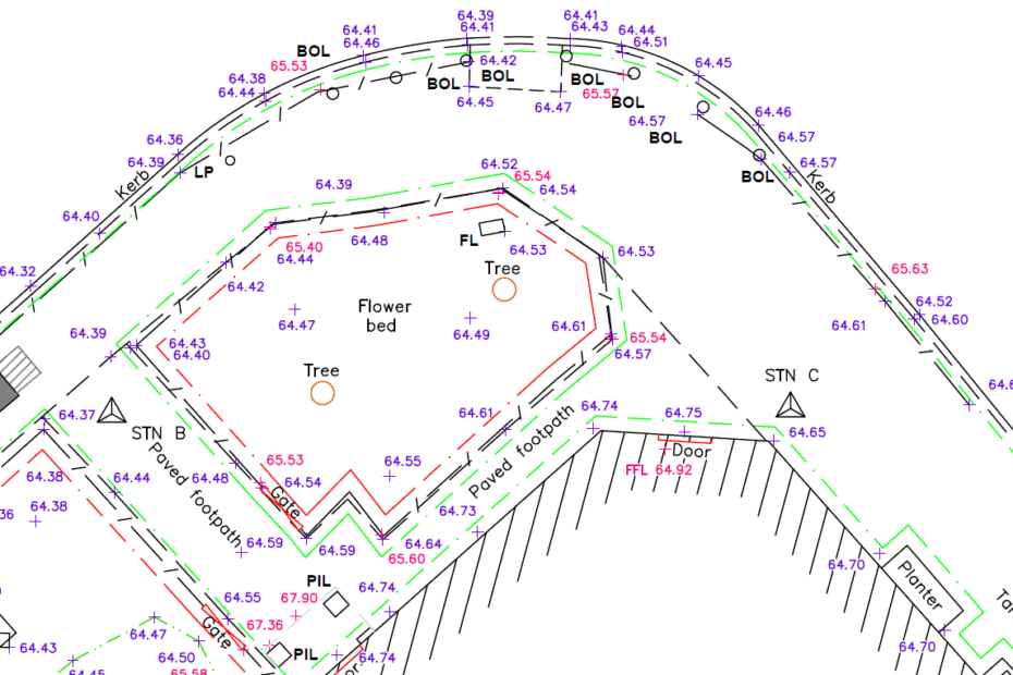
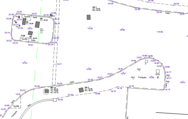
A topographical or land survey captures the topography across a specific site or given area.
This is carried out using a theodolite / Electronic Distance Measurer (EDM) to accurately record visible hard & soft features with the aim of providing a scaled drawing of that site.
These features include, boundary features, vegetation and tree lines, individual trees where standalone, building lines, changes of surface and other pertinent hard features as defined by Royal Institute of Chartered Surveyors (RICS).
This can also include bottom and top of kerbs, gate posts, gates, doors and openings, fences, walls, embankments, street furniture, roof eave and ridge heights among others.
Ground levels or spot heights at various intervals are also recorded, referenced to Global Positioning Satellites (GPS) using the UK grid OSGB36 2015 or an arbitrary grid.
An example is shown below:
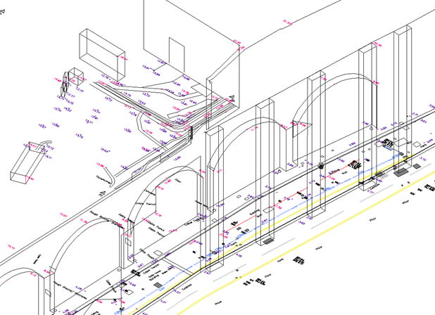
Results relating to Topographical or Land Surveys can be provided in 2D plan view and as a 3D output, usually as 3D polylines, with height information recorded to Z.
An example of this is below:
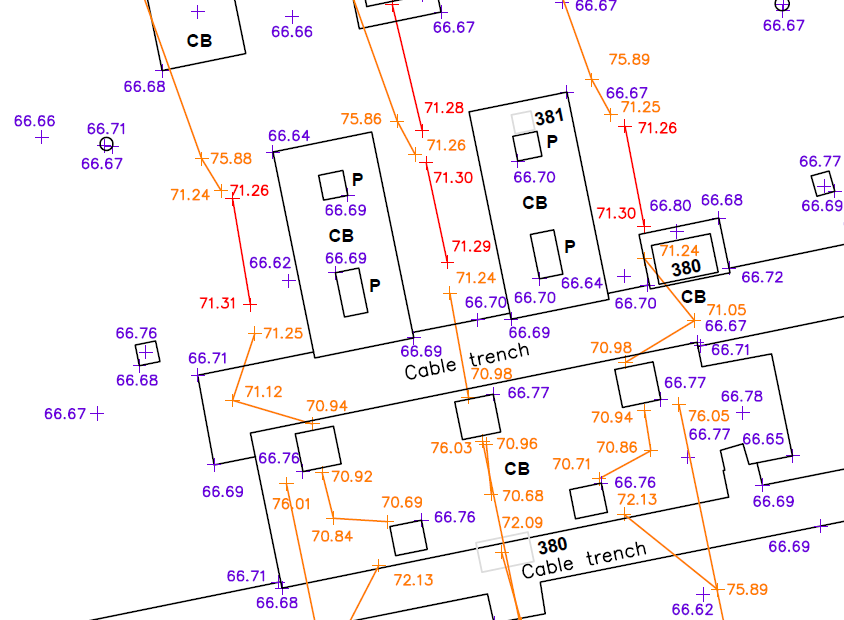
Why do GEOTEC carry out a topographical survey alongside a Utility Mapping Survey?
When we detect a buried service or utility, we mark its location and depth onto the ground surface in spray paint.
To accurately portray the location of this service we topographically record the spray mark relating to its position into an EDM
We also capture other hard features such as manhole covers and building lines so that we have a suitable level of topographical / above-ground features reference data to produce an accurate AutoCAD base drawing showing the buried services and utilities on a given site.
The two surveys go hand in hand.
What are the methods of topographical survey?
Topographical Surveys or Land Surveys are carried out using Electronic Distance Measurers or EDM’s.
Survey control is usually established first and then the hard features are recorded.
Accuracy is achieved using the triangulation or traverse method.
GEOTEC Topographical Surveys are positions onto GPS or an arbitrary grid reference.
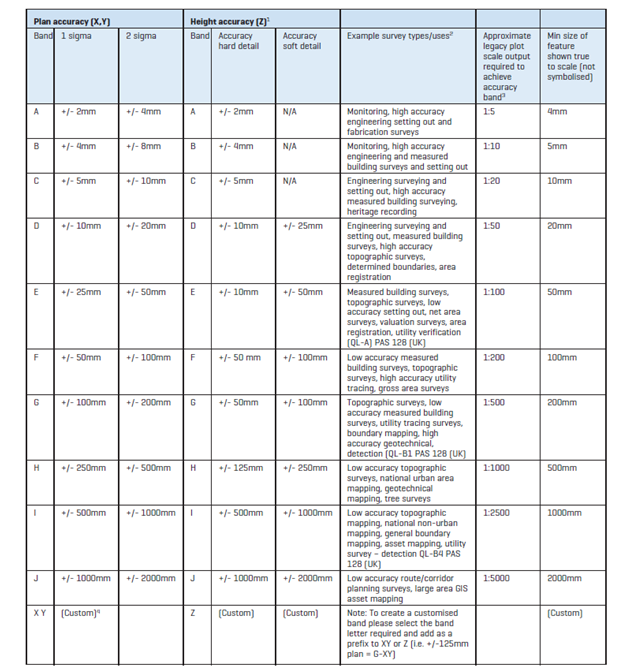
How accurate is a topographical survey?
There are various levels of accuracy which can be achieved, and this is down to the survey control network that is established. RICS offer the following guide.
A GEOTEC Surveys Topographical Survey usually falls into Band D or E.
A topographical or land survey captures the topography across a specific site or given area.
This is carried out using a theodolite / Electronic Distance Measurer (EDM) to accurately record visible hard & soft features with the aim of providing a scaled drawing of that site.
These features include, boundary features, vegetation and tree lines, individual trees where standalone, building lines, changes of surface and other pertinent hard features as defined by Royal Institute of Chartered Surveyors (RICS).
This can also include bottom and top of kerbs, gate posts, gates, doors and openings, fences, walls, embankments, street furniture, roof eave and ridge heights among others.
Ground levels or spot heights at various intervals are also recorded, referenced to Global Positioning Satellites (GPS) using the UK grid OSGB36 2015 or an arbitrary grid.
An example is shown below:
Results relating to Topographical or Land Surveys can be provided in 2D plan view and as a 3D output, usually as 3D polylines, with height information recorded to Z.
An example of this is below:
When we detect a buried service or utility, we mark its location and depth onto the ground surface in spray paint.
To accurately portray the location of this service we topographically record the spray mark relating to its position into an EDM
We also capture other hard features such as manhole covers and building lines so that we have a suitable level of topographical / above-ground features reference data to produce an accurate AutoCAD base drawing showing the buried services and utilities on a given site.
The two surveys go hand in hand.
Topographical Surveys or Land Surveys are carried out using Electronic Distance Measurers or EDM’s.
Survey control is usually established first and then the hard features are recorded.
Accuracy is achieved using the triangulation or traverse method.
GEOTEC Topographical Surveys are positions onto GPS or an arbitrary grid reference.
There are various levels of accuracy which can be achieved, and this is down to the survey control network that is established. RICS offer the following guide.
A GEOTEC Surveys Topographical Survey usually falls into Band D or E.


