
Vehicle Mounted GPR Surveys
Geotec uses a vehicle-mounted multi-channel GPR tow-along system to detect subsurface features in live traffic, eliminating or reducing the need for traffic management measures.
Applications:
- As part of a combined utility mapping survey alongside traditional underground mapping survey techniques to provide high quality, comprehensive survey results to PAS 128.
- A stand-alone survey for buried services and utilities to detect unidentified targets, which can be cross-referenced with statutory records information where a high-level survey is required.
- Ideal for roads where traffic management measures may be difficult to obtain, complex or expensive and where there is not an abundance of manhole covers or buried services present.
- On large, flat, open sites to detect old building lines, tunnels, voids and other such features as illustrated below:
Want to know more about VM GPR Surveys?
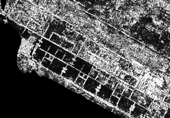
Example survey for building lines using vehicle mounted GPR system
Underground
Mapping
An example of a survey where several unidentified ground penetrating radar targets are present, along with confirmed buried services and utilities.
This tool also enables the confirmation of the presence of metallic and conductive services that have already been detected through radio frequency detection/electromagnetic locating (RFD/EML).
PAS 128 Surveys
Utility Mapping / Buried Services Surveys
GPR Surveys
Service Clearance / Marking Out Surveys
Popular FAQs for Vehicle-Mounted GPR Surveys
A Vehicle-Mounted GPR Survey comprises utility mapping by way of a Ground Penetrating Radar (GPR) system, installed onto the rear of a suitable vehicle, which scans the road at an appropriate speed to collect the necessary data.
The evaluation of this data will identify unknown targets which can be cross-referenced against statutory record information (stats) or combined with a radio frequency detection survey (EML), which will confirm targets or identify other services, not yet located, such as plastic gases and waters.
This approach differs from a traditional survey, which is completed using a cart-based GPR solution, pushed by a surveyor, on an orthogonal grid formation across any given site. The vehicle-mounted system blanket surveys the site, with no gaps.
We primarily use the vehicle-mounted GPR for the detection and mapping of buried services and utilities; however, we have also had success in mapping old building lines at a barracks, as well as voiding in & beneath concrete slabs at an airport. Different approaches and solutions can be sought for different objectives & applications, such as road construction analysis.
Vehicle-mounted GPR Surveys are primarily used for utility mapping and road construction analysis; however, we mainly focus on utilities.
They are more accurate than traditional GPR surveys as they are completed using a multi-channel antenna, on a blanket basis, meaning that the pool of data collected is much larger. The evaluation software used is advanced and can extract findings and targets more easily by eradicating unwanted noise from the dataset.
Yes, we use a system which can be driven at traffic speeds, however we tend to complete these surveys at night when there is less traffic on the road and have an escort vehicle following behind, with Chapter 8 signage and flashing beacons to ensure that these surveys are completed as safely as possible.
Results usually take a week to be produced after the survey has been completed; however, if a larger site is being completed, then this will increase accordingly.
The size of the site, the number of roads and the number of kilometres which require surveying. Time (and cost) can also be affected by how many junctions and obstructions are present, parked vehicles and other such traffic-based factors. Data processing time is determined by the amount of data that is collected and the subsequent production. Background data is also key, as is the ability to obtain GPS positioning.
Please call us on 01428 686168 or email enq@geotecsurveys.com to speak to a member of our team.
Our surveyors all hold a full UK Driving license (or equivalent) and GEOTEC hold Euro GPR membership.
Talk to Geotec


Follow Online
© GEOTEC SURVEYS – UNDERGROUND MAPPING


Website designed and produced by expect more – part of snap-marketing.co.uk
Website designed and produced by
expect-more.co.uk