
Introduction
GEOTEC Surveys Ltd was invited to provide a competitive tender response in relation to the provision of PAS 128 GeoTec Underground Mapping Surveys at Haverfordwest High School and Milford Haven Secondary School by the Pembrokeshire County Council.
GEOTEC was awarded the work following a successful tendering exercise.
The survey areas consisted of the whole school site, associated hard-standing and soft landscaping around existing buildings, as well as the playing fields at each location.
At Haverfordwest, this is related to an area of around 55,000 square metres and 115,000 square metres at Milford Haven.
Haverfordwest High School
The proposal is for the redevelopment of the new Haverfordwest High School, which will deliver a new 11-19 English Medium School on the site of the old Sir Thomas Picton School site as part of Band B of the C21st Schools Programme. The project is currently at the feasibility stage but is likely to include a new 1750-pupil school.
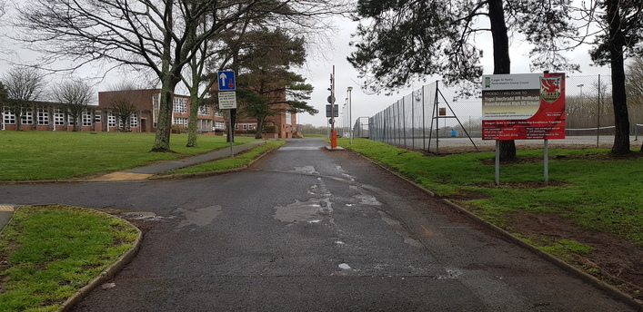
PHOTOGRAPH OF HAVERFORDWEST HIGH SCHOOL
Milford Haven Secondary School
The proposal is for Pembrokeshire County Council to formally invite tenders to refurbish and/or extend the current Milford Haven Secondary School.
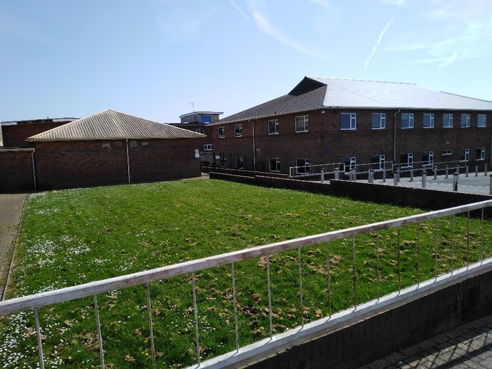
PHOTOGRAPH OF MILFORD HAVEN SECONDARY SCHOOL
As part of this the client had stipulated a need to provide an accurate CAD record drawing of both known and unknown utility services within the boundaries using all appropriate survey tools to identify, verify, locate and plot the below ground utility services.
The external survey was requested to be in accordance with BSI PAS 128:2014 to achieve a QL-B1P quality level.
To support our onsite activities and to cross reference when producing our final survey results, we also procured the necessary statutory undertakers records. These are invaluable when attempting to establish what seemingly unidentified services may be.
The client provided a topographical survey in DWG for each site, for us to overlay our survey results onto relating to the buried services and utilities. This decreased the amount of topographical surveying that our surveyors needed to complete.
Operations
The client stipulated within their tender documentation that survey works at Haverfordwest needed to be completed during the course of the February half-term and that survey works at Milford Haven had to be completed over the Easter break, when students, staff, and visitors would not be present.
We liaised with the caretaking staff at each location to ensure that access was available to all areas during these times.
Due to the size & complexity of the survey area at Haverfordwest and the deadline of 1 week to complete all site works, we utilised two 2-person survey teams, who traveled to the site on a Sunday and returned on a Saturday night.
Similarly, for Milford Haven, we utilised two 2-person survey teams who traveled to the site on the weekend and worked through Easter to complete survey works within the fortnight window available to us.
Both sites were divided into sections where each team would be responsible for lifting manhole covers, gullies, and valves and tracing these services using radio frequency detectors and transmitters which were induced onto each service from these access points.
In the case of ducts and drainage, to which the majority of services are related, a copper core line threader was inserted into each line and a signal was then induced into that and traced in order to provide a line, level, and depth.
These findings were then sprayed onto the ground surface in temporary spot-marking spray paint (so as to not remain onsite for a sustained period of time after the survey was completed).
Once the services were traced out from these access points, the team employed the radio frequency detectors passively to detect any other metallic or conductive linear features running across the site.
Lastly, in terms of service detection, each site was surveyed over an orthogonal grid with the use of a Ground Penetrating Radar System. In this instance, we used a SIR system with a 400MHz GPR antenna, designed to search to depths of 2m below the ground surface.
The level of resource allocated to this undertaking was necessary to ensure that a suitably tight grid was adopted using the Ground Penetrating Radar in order to verify services already located and to pick up those which had not previously been picked up so that PAS 128 GeoTec methodology was achieved.
As part of this project, a manhole schedule was required, for example below, which proved a significant exercise as Haverfordwest School had 140 manholes onsite and Milford Haven had 96 manholes.
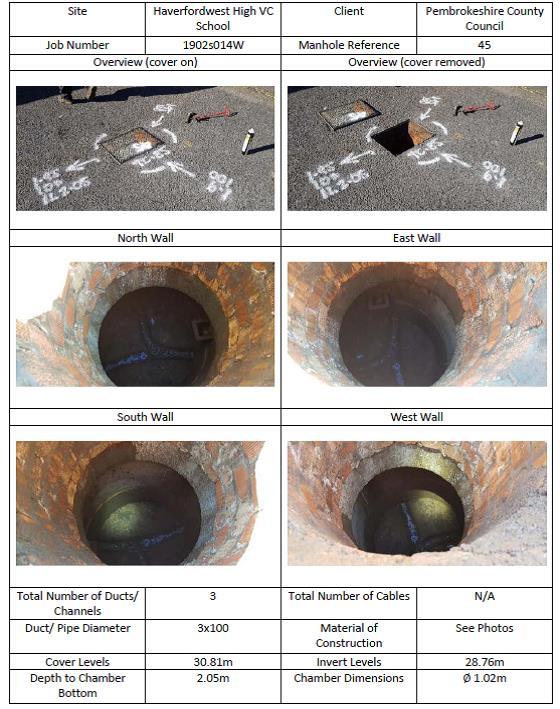
EXAMPLE OF A MANHOLE SCHEDULE DATA SHEET
The survey teams then recorded all ‘marked out’ data including radar grid positions using a calibrated EDM/theodolite so that all underground information could be accurately tied to a fixed above ground point.
Introduction
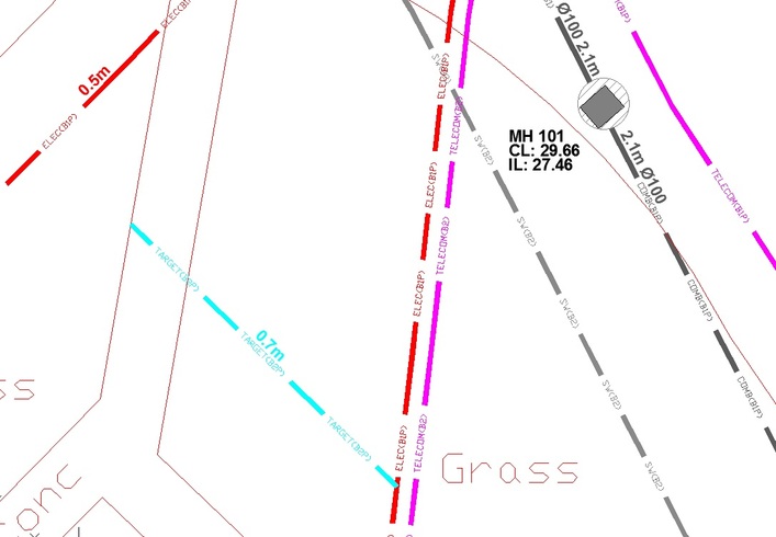
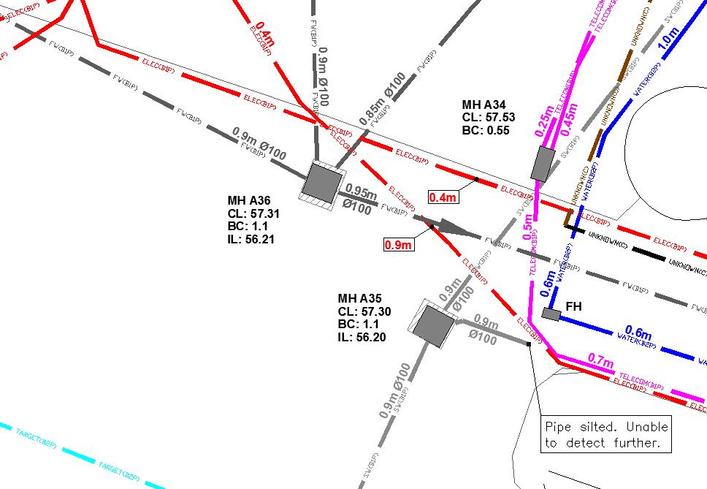
Results were then presented in 2D plan view pdf and dwg formats in line with PAS 128 GeoTec, as shown in the below table.
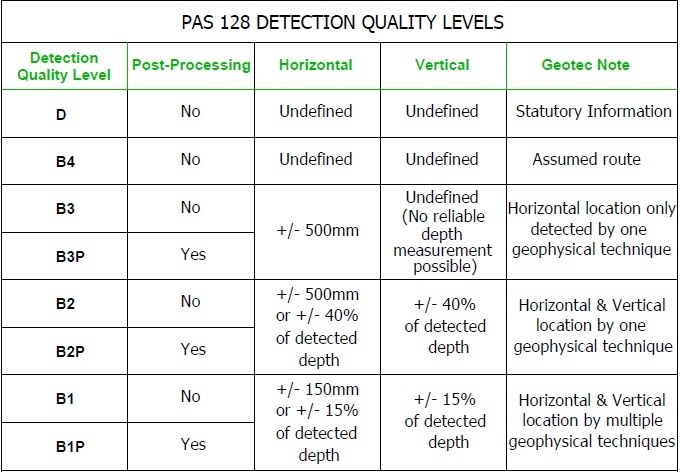
PAS 128 DETECTION LEVELS
Both schools were heavily congested with services and overviews of the sites together with zoomed in extracts are displayed below:
Haverfordwest
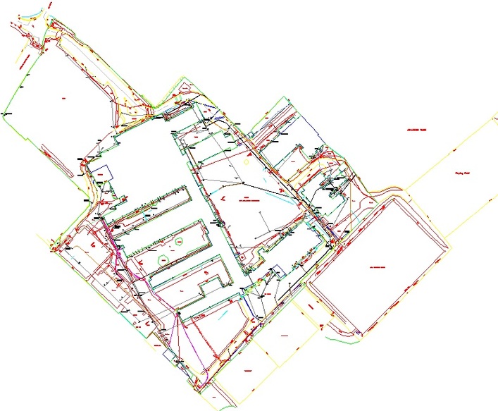
HAVERFORDWEST OVERVIEW & EXTRACT OF RESULTS
Milford Haven
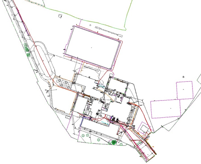
MILFORD HAVEN OVERVIEW & EXTRACT OF RESULTS
The quality level allocated to each detected service (B1 to B4), illustrates the level of confidence that can be attributed to each service position in terms of horizontal and vertical accuracy.
This can then allow the client to make decisions regarding whether trial holes or vacuum excavation would be required (to fulfill level A of PAS 128) to verify our survey results in key areas.
Overall, our survey results will assist in the design decision-making for each school & assist contractors when it comes to breaking ground.
They may be used to identify the most appropriate location for any extension works to take place & inform the client, the designers, and the contractors where services enter the site and where best to situate temporary classrooms.
The accompanying manhole schedule can be used to identify drainage and duct capacities which may also have a bearing on any extension design.
In the short term, our outputs will be forwarded to relevant contractors & designers to enable them to provide an accurate tender response for the works, once defined.
The survey results offer an excellent and informed starting point from which an options appraisal can then be undertaken.
 +44 (0)1428 686 168
 enq@geotecsurveys.com


