Gillespie Statue GPR Survey, County Down

NEWS 08/09/2024

GEOTEC GPR Survey Case Study

Background

“Whilst leading an attack on a fort, high in the Himalayas, Gillespie went on despite having no ammunition shouting “one more shot for the honour of Down”.

Born in Comber in 1766, Gillespie was killed at Kalunga in 1814 leading the main assault during the Battle of Nalapani during the Anglo Nepal War.

A hero in the town, Gillespie’s statue was unveiled on 24 June 1845 and comprises a free-standing sandstone square shaft column on a square stepped podium.

GPR Surveys Ireland

Statue of Major General Robert Rolo Gillespie in Comber, Co.Down

In need of renovation, Ards and North Down Borough Council agreed to initial investigation and the first stage of renovation works, estimated to cost around £15k, in February 2024.

As a result, Alastair Coey Architects contacted GEOTEC Surveys Ltd to complete a Ground Penetrating Radar & Electromagnetic Survey to locate metallic structural supports within the statue and any potential voiding within the associated stonework.

OPERATIONS

Survey works took place over Tuesday 16th and Wednesday 17th April 2024 and extensive scaffolding had been erected around the monument, in order to provide the survey team with safe access.

GPR Survey Ireland

Statue with Scaffold

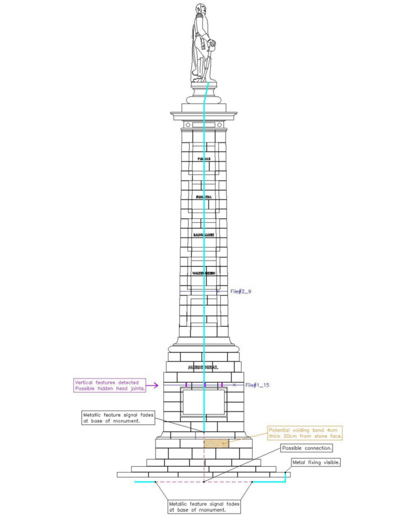
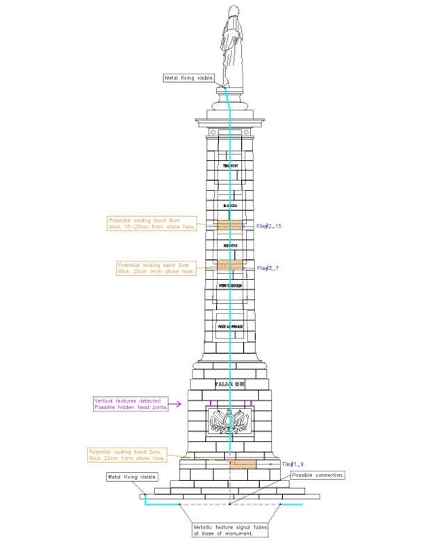
The survey was conducted using a GSSI StructureScan Mini XT Ground Penetrating Radar (GPR), due to its portable & self-contained nature, which employs a 2.7GHz antenna to provide high near surface resolution.

The StructureScan Mini XT is specifically designed to detect reinforcing bars in stone and concrete and has a maximum depth penetration of 60cm. The system gained good quality data through the sandstone to this depth.

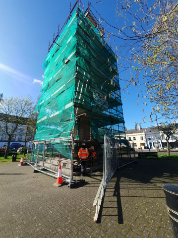
The below photo shows the StructureScan Mini XT and radar file markings on the statue, in chalk.

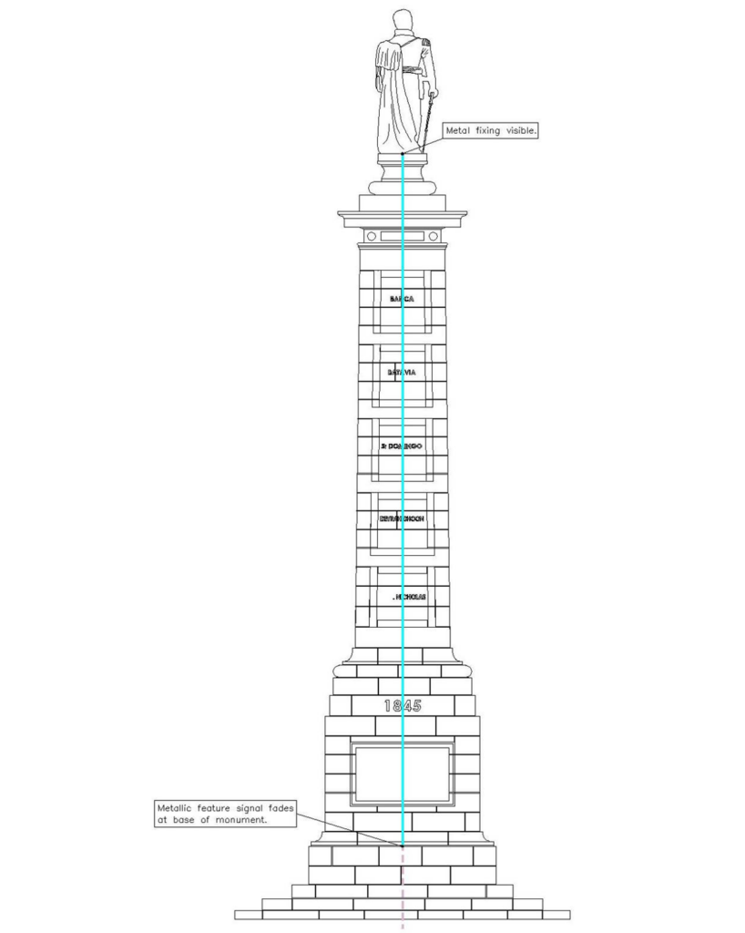
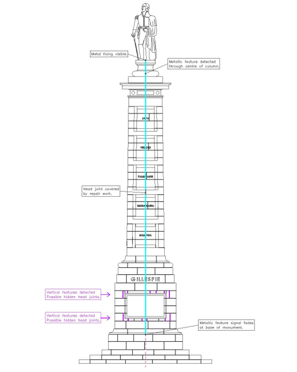
We also utilised a radio-frequency location tool, designed to detect metallic and conductive targets.

Using the Radio Frequency Detector, we induced an electromagnetic signal into the exposed metal fixing at the feet of the statue (at the top) & and on the lowest step of the base which allowed us to trace the signal through the whole column.

Results

The radio frequency detection survey found that metallic rod connecting the statue and the base may not currently be connected in its entirety. The two induction points may have been securely connected at some point, with the metalwork deteriorating over time.

The electromagnetic signal induced into the metal fixings was detected down the length of the column into the base, and possibly connects into a horizontal feature below ground level.

Areas of potential voiding were detected; each area was well defined by a single stone at the monument surface.

The most likely explanation for this would be that some of the stones are slightly shallower in depth and that a gap, or area of less dense material exists behind, in order to keep the façade even.

There was no obvious evidence of a structural void in the data collected.

The below drawing extracts detail the findings. The blue lines indicate where metal structural support may be present & the areas of hatching illustrate areas of potential voiding.

GPR Survey Mini Scan Findings England

Elevation 1: North-West elevation

GPR Survey Mini Scan Surrey

ELEVATION 2: NORTH-EAST ELEVATION

GPR Survey mini scan findings 3

Elevation 3: South-East elevation

Mini GPR Survey Scan Findings

Elevation 4: South-West elevation

London Borough Lambeth

GEOTEC Surveys worked with London Borough of Lambeth to provide a PAS128 Underground Utility Mapping and GPR Survey outside Waterloo Station to support the design of a footway buildout and installation of a Copenhagen style crossing in Mepham Street.

Portsmouth Water

GEOTEC Surveys supported Portsmouth Water in providing a 3D PAS 128 Underground Mapping & GPR Survey for the proposed reservoir pipeline route over 3.8km in 2020.

Pembrokeshire County Council

GEOTEC Surveys Ltd completed 2x comprehensive PAS 128 Surveys over the February Half Term and Easter Holiday Period at Haverfordwest High School & Milford Haven Secondary School in Pembrokeshire.

Case Studies

FURTHER READING

For an in-depth review of Geotecs most recent underground mapping projects see the case studies that are featured throughout the website.

Alternatively please click the link below to explore the resources section.

Request a survey