GPR Surveys
GPR Surveys
Ground Penetrating Radar (GPR) antennae is used to search for features at a variety of depths.
Ground Penetrating Radar (GPR) is a versatile tool which can be used to meet a range of objectives:
- Buried services and utilities, in particular drainage, culverts and plastic pipes
- Changes in density relating to voiding or unconsolidated ground.
- The presence of subsurface features such as obstructions, tanks, pile caps and building lines
- Saturated ground conditions and wash associated with leaks
- Graves, crypts, tombs, basements and cellars
- Reinforcing and rebar in concrete slabs and concrete thicknesses
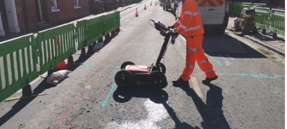
Standard digital hyper-stacking GPR system is part of a Utility Mapping Survey
Geotec primarily use GPR when carrying out PAS 128 and buried services/utility mapping surveys, and this system is invaluable in detecting non-conductive and non-metallic buried services and utilities such as plastic water & gas pipes, drainage and culvert routes.
Want to know more about GPR Surveys?
This tool also allows us to confirm the presence of metallic and conductive services that have already been detected through radio frequency detection / electro-magnetic locating (RFD / EML).
Geotec can combine a range of GPR antennae to search for features at a variety of depths in order to best meet your needs:
- Handheld GPR System 0-450mm (below ground level)
- Shallow antenna 0-1m
- Standard antenna 0.1-3m – this is the primary tool we use for utility mapping surveys
- Deeper antenna 2-10m •
- Dual frequency antenna
Underground
Mapping
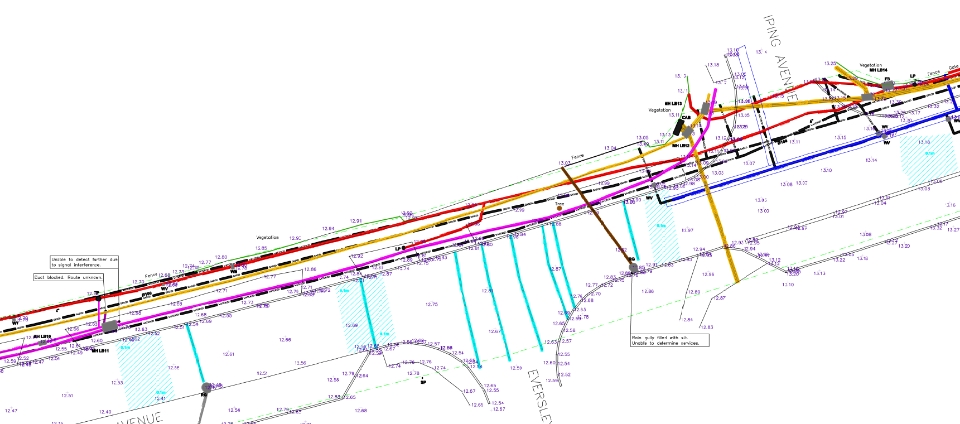
An example of a survey where several unidentified ground penetrating radar targets are present, along with confirmed buried services and utilities.
This tool also enables Geotec to confirm the presence of metallic and conductive services that have already been detected through radio frequency detection/electromagnetic locating (RFD/EML).
PAS 128 Surveys
Vehicle Mounted GPR Surveys
Utility Mapping / Buried Services Surveys
Service Clearance / Marking Out Surveys
GPR Survey FAQ’s
Below are a list of questions that we are asked on a regular basis about GPR Surveys for Utility Mapping:
What is a GPR survey for?
A Ground Penetrating Radar (GPR) Survey is used to detect changes in ground density.
These changes may relate to:
Buried Services & Utilities – we utilise GPR every day as part of our utility surveys and it is an integral tool in detecting plastic gas and water, as well as other services such as drainage.
Voiding and Unconsolidated Ground – voiding such as tunnels, cavities or disturbed / looser ground.
Significant buried features such as tanks, foundations or other substantial obstructions.
Saturated ground conditions – this is identified by a significant degradation of radar data. When paired with a utility survey, this may identify where leaks could be present. Voiding may be associated with wash.
How much does a GPR survey cost in the UK?
The cost of a survey depends on a number of factors:
- Objective of the survey
- Depth survey needs to penetrate
- Size and nature of the survey area
- Geographical location of the site
- Whether any out-of-hours working or traffic management measures are required.
How accurate are GPR surveys?
Utility Mapping Surveys have a tolerance of the 10% of the depth down to 2m below the ground surface.
This tolerance increases significantly beyond 2m.
A number of factors affect the accuracy of the Ground Penetrating Radar, such as ground conditions. For example, dry sand is the best medium for getting the most from a GPR system, whilst wet sand is the worst!
What are the disadvantages of GPR survey?
Ground Penetrating Radar on its own cannot tell you what a specific feature or anomaly may relate to. Use of radio frequency detection or excavation can assist in identifying what anomalies or unidentified linear targets may be.
GPR cannot be used where vegetation or obstructions are present and is not practical where long grass or uneven ground is in situ.
The presence of reinforced concrete also limits the effectiveness of GPR.
How deep can GPR survey go?
Ground Penetrating Radar is a versatile tool which can be tailored for a range of applications.
We use a handheld GPR system which has a depth penetration of 400mm below the ground surface for concrete analysis and locating anomalies in small, often, internal spaces including underfloor heating pipes and voids.
There are antennas which offer high resolution at shallow depths.
Next, we have dual antenna systems which provide high resolution output at a shallow depth and a deeper depth.
Our standard set up consists of a 350MHz hyper-stacking digital antenna or 400MHz antenna designed for detecting buried services and utilities.
We can then use 200, 270 or 100MHz GPR antenna for deeper depth penetration up to 10m, subject to ground conditions.
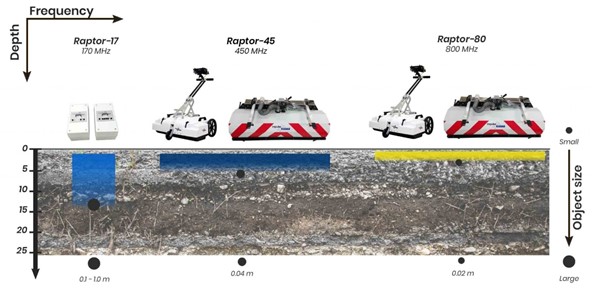
The smaller the feature, the harder it is to detect. The deeper we penetrate the larger the feature has to be for it to be picked up in the radar data. This is displayed by the below graphic:
Vehicle-mounted GPR surveys are designed to cover large area or highways quickly. This is completed using a multi-array or multi-channel system.
How do you display or present GPR Survey Results?
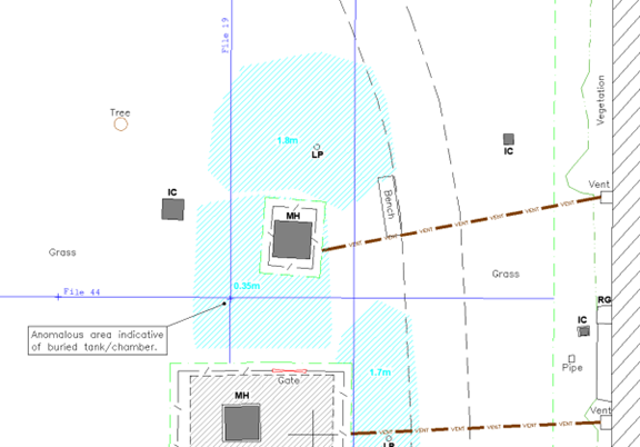
GEOTEC Surveys indicate the presence of an anomaly by the below turquoise hatching. The depth to the top of the anomaly is also shown.
Where enough evidence is present, we shall also attempt to identify what the anomaly may relate to.
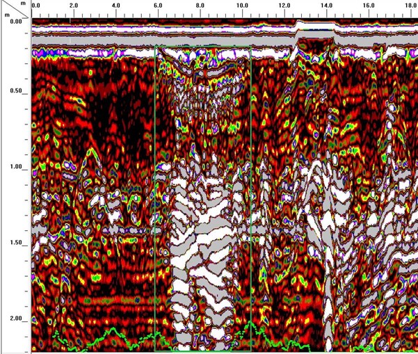
GEOTEC can also provide an accompanying report which includes some extracts of the data collected using the Ground Penetrating Radar System.
We would highlight which file the extract relates to and highlight the area of interest using the green boundary line on the below example.
File 44:
We also use other software packages, where required, which processes the data to enable us to view it in line with the below representations:
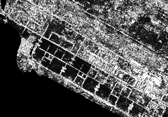
The above extract shows the presence of former building lines on an old barracks site.
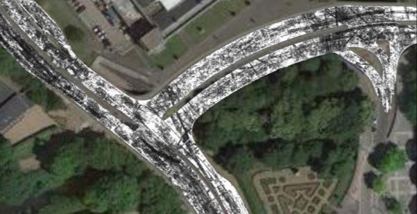
The below extract shows the positions of buried services and utilities on a highways project in Wales, overlaid onto Google Earth data.
GPR Survey FAQ’s
Below are a list of questions that we are asked on a regular basis about GPR Surveys for Utility Mapping:
A Ground Penetrating Radar (GPR) Survey is used to detect changes in ground density.
These changes may relate to:
Buried Services & Utilities – we utilise GPR every day as part of our utility surveys and it is an integral tool in detecting plastic gas and water, as well as other services such as drainage.
Voiding and Unconsolidated Ground – voiding such as tunnels, cavities or disturbed / looser ground.
Significant buried features such as tanks, foundations or other substantial obstructions.
Saturated ground conditions – this is identified by a significant degradation of radar data. When paired with a utility survey, this may identify where leaks could be present. Voiding may be associated with wash.
The cost of a survey depends on a number of factors:
- Objective of the survey
- Depth survey needs to penetrate
- Size and nature of the survey area
- Geographical location of the site
- Whether any out-of-hours working or traffic management measures are required.
Utility Mapping Surveys have a tolerance of the 10% of the depth down to 2m below the ground surface.
This tolerance increases significantly beyond 2m.
A number of factors affect the accuracy of the Ground Penetrating Radar, such as ground conditions. For example, dry sand is the best medium for getting the most from a GPR system, whilst wet sand is the worst!
Ground Penetrating Radar on its own cannot tell you what a specific feature or anomaly may relate to. Use of radio frequency detection or excavation can assist in identifying what anomalies or unidentified linear targets may be.
GPR cannot be used where vegetation or obstructions are present and is not practical where long grass or uneven ground is in situ.
The presence of reinforced concrete also limits the effectiveness of GPR.
Ground Penetrating Radar is a versatile tool which can be tailored for a range of applications.
We use a handheld GPR system which has a depth penetration of 400mm below the ground surface for concrete analysis and locating anomalies in small, often, internal spaces including underfloor heating pipes and voids.
There are antennas which offer high resolution at shallow depths.
Next, we have dual antenna systems which provide high resolution output at a shallow depth and a deeper depth.
Our standard set up consists of a 350MHz hyper-stacking digital antenna or 400MHz antenna designed for detecting buried services and utilities.
We can then use 200, 270 or 100MHz GPR antenna for deeper depth penetration up to 10m, subject to ground conditions.
The smaller the feature, the harder it is to detect. The deeper we penetrate the larger the feature has to be for it to be picked up in the radar data. This is displayed by the below graphic:

Vehicle-mounted GPR surveys are designed to cover large area or highways quickly. This is completed using a multi-array or multi-channel system.
GEOTEC Surveys indicate the presence of an anomaly by the below turquoise hatching. The depth to the top of the anomaly is also shown.

Where enough evidence is present, we shall also attempt to identify what the anomaly may relate to.
GEOTEC can also provide an accompanying report which includes some extracts of the data collected using the Ground Penetrating Radar System.
We would highlight which file the extract relates to and highlight the area of interest using the green boundary line on the below example.
File 44:

We also use other software packages, where required, which processes the data to enable us to view it in line with the below representations:

The above extract shows the presence of former building lines on an old barracks site.
The below extract shows the positions of buried services and utilities on a highways project in Wales, overlaid onto Google Earth data.

Talk to Geotec
Follow Online
© GEOTEC SURVEYS – UNDERGROUND MAPPING


Website designed and produced by expect more – part of snap-marketing.co.uk
Website designed and produced by
expect-more.co.uk


