
Utility Mapping Buried Services Surveys
Utility Mapping Buried Services Surveys
Comprehensive Detection with EML and GPR as Standard.
A GEOTEC underground utility mapping survey is one of the most comprehensive services in the industry, utilising radio frequency detection / electromagnetic locating (EML) & ground penetrating radar (GPR) as a minimum.
This also includes investigating manholes, inspections chambers, gullies, valves and other access points such as plant rooms, substations and boiler houses to directly trace the routes of known and unknown buried services.
Findings are topographically recorded, offering accurate results presented in AutoCAD 2D or 3D DWG or PDF formats.
Geotec can also carry out CCTV Surveys on drainage.
Geotec look to detect metallic and non-metallic services, including:
- Water
- Power
- Gas
- Telecommunications
- Fibre Optics
- Drainage
- Fuel & Oil
- District Heating
- Other linear targets
- GPR can also detect and map subsurface anomalies such as voids and obstructions
Want to know more about Utility Mapping Surveys?
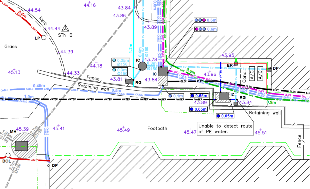
Here’s an example of the results
Underground
Mapping
An example of a survey where several unidentified ground penetrating radar targets are present, along with confirmed buried services and utilities.
This tool also enables confirmation of the presence of metallic and conductive services that have already been detected through radio frequency detection/electromagnetic locating (RFD/EML).
PAS 128 Surveys
GPR Surveys
Vehicle Mounted GPR Surveys
Service Clearance / Marking Out Surveys
Talk to Geotec


Follow Online
© GEOTEC SURVEYS – UNDERGROUND MAPPING


Website designed and produced by expect more – part of snap-marketing.co.uk
Website designed and produced by
expect-more.co.uk